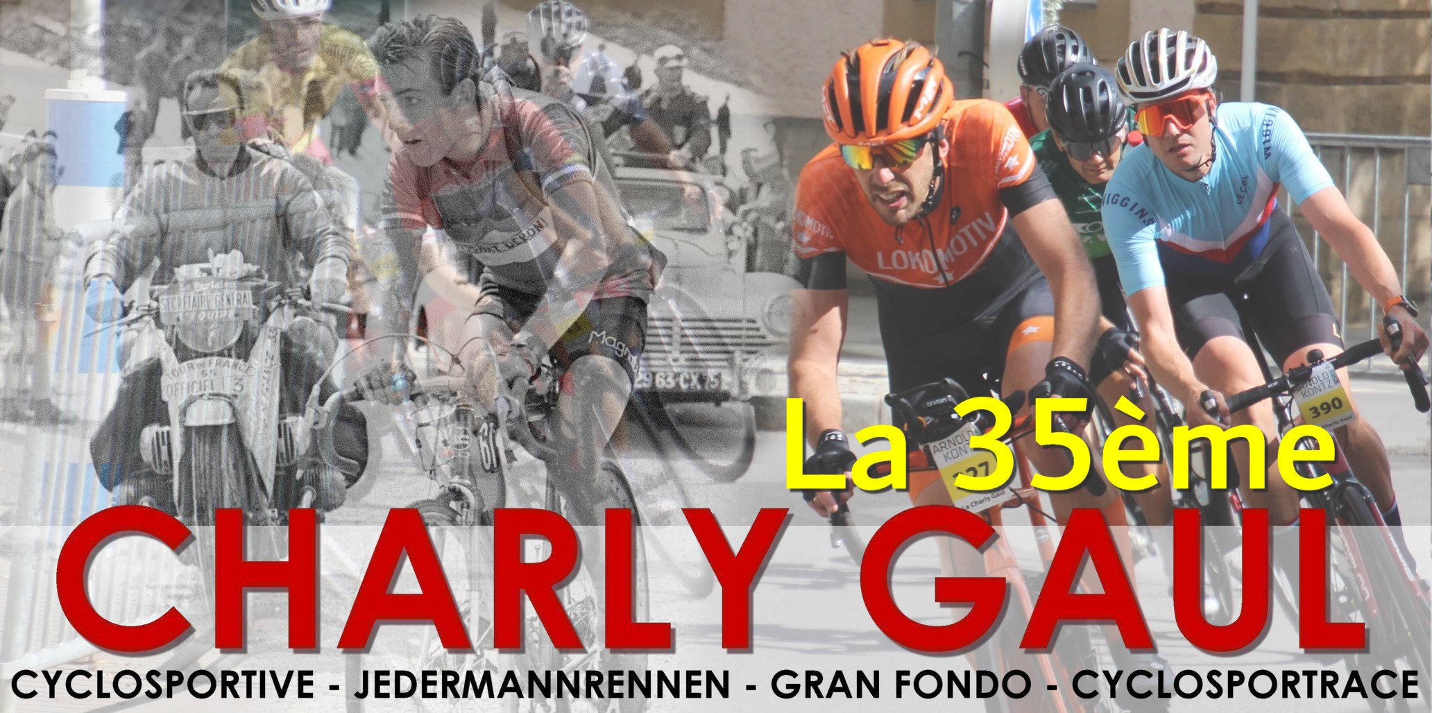
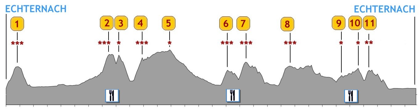
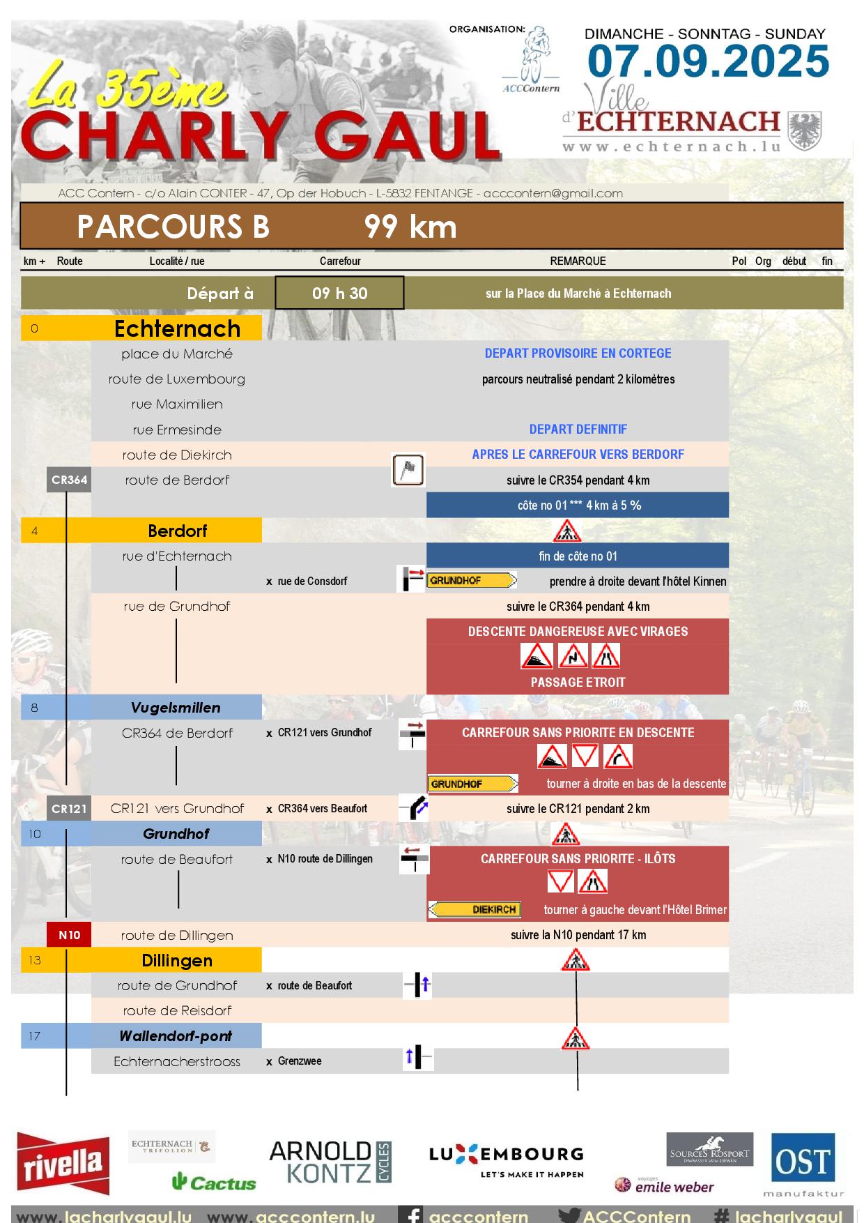
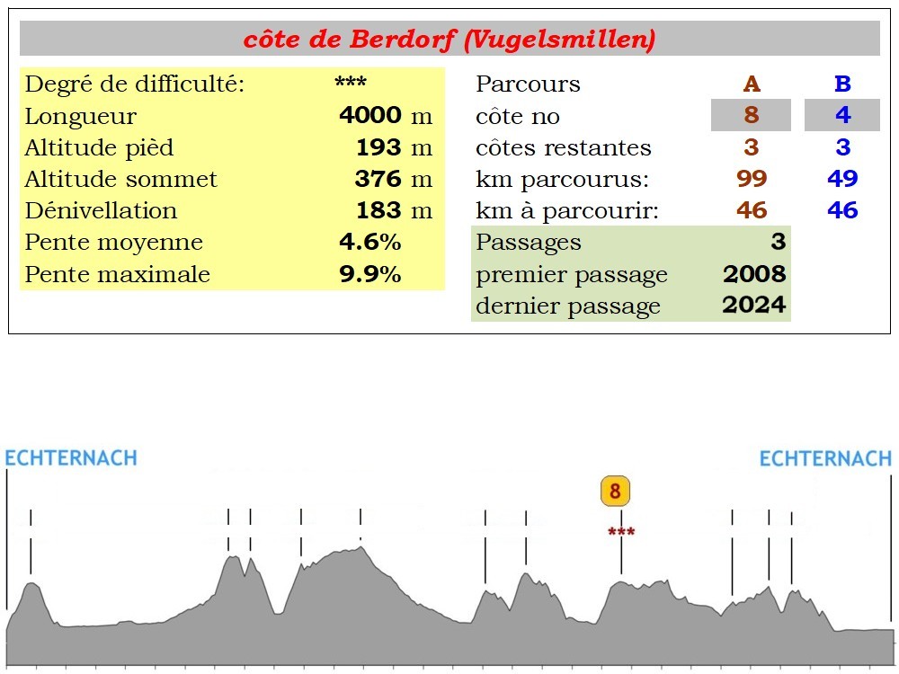
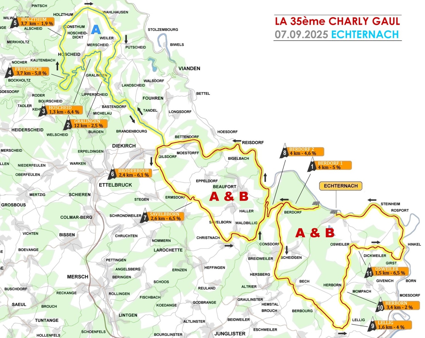
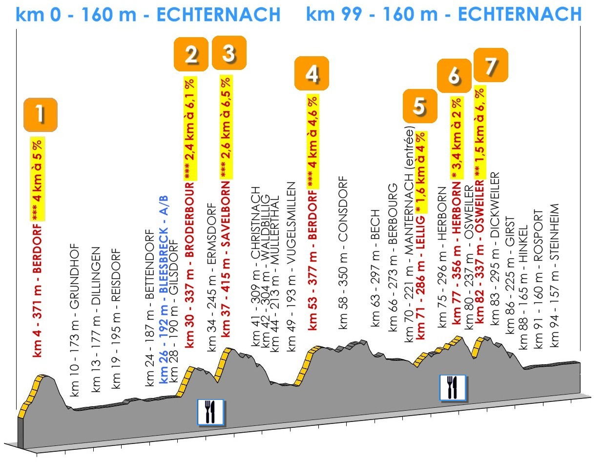
La 35ème Charly Gaul propose deux parcours aux concurrents, comme les années précédentes, mais avec un départ commun. Le parcours le plus long totalise 149 kilomètres et plus de 2.000 mètres de dénivellation répartis sur 11 côtes, tandis que le parcours B mesure 99 kilomètres et comprend 7 côtes pour un total de plus ou moins 1.250 mètres de dénivellation.
Une fois n'est pas coutume, les deux parcours sont quasiment identiques à ceux de l'année précédente.
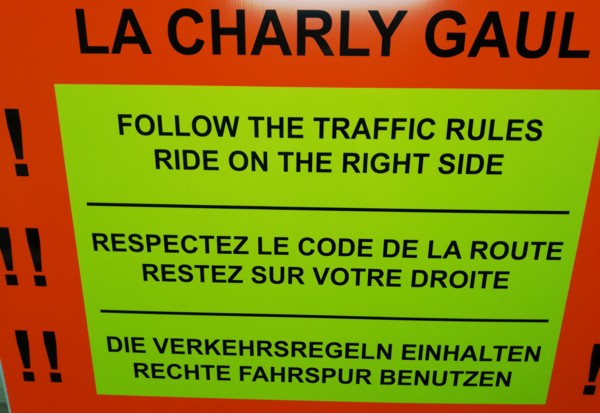
La stricte observation du code de la route est imposée aux coureurs
|
|
|
|
|
|
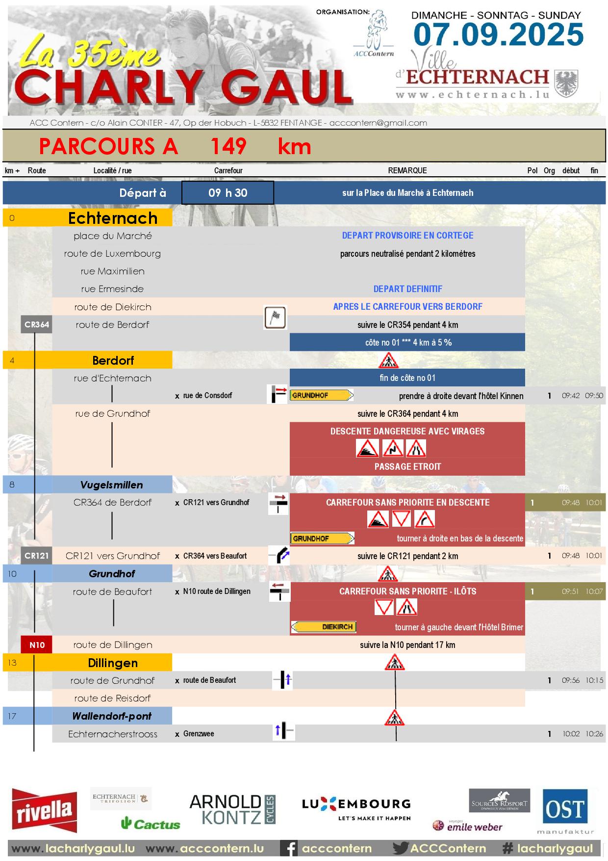
Départ à 9h30 sur la place du Marché à Echternach
|
|
km +
|
Localité
|
Remarque
|
Route
|
km -
|
Alt
|

|
|
0
|
ECHTERNACH
|
DEPART
|
CR364
|
149
|
160
|
|
4
|
Berdorf
|
|
|
|
145
|
371
|
|
8
|
Vugelsmillen
|
|
CR121
|
141
|
187
|
|
10
|
Grundhof
|
|
N10
|
139
|
173
|
|
13
|
Dillingen
|
|
|
|
136
|
177
|
|
19
|
Reisdorf
|
|
N19
|
130
|
195
|
|
22
|
Moestroff
|
|
|
|
127
|
186
|
|
24
|
Bettendorf
|
|
|
|
125
|
187
|
|
26
|
Bleesbreck
|
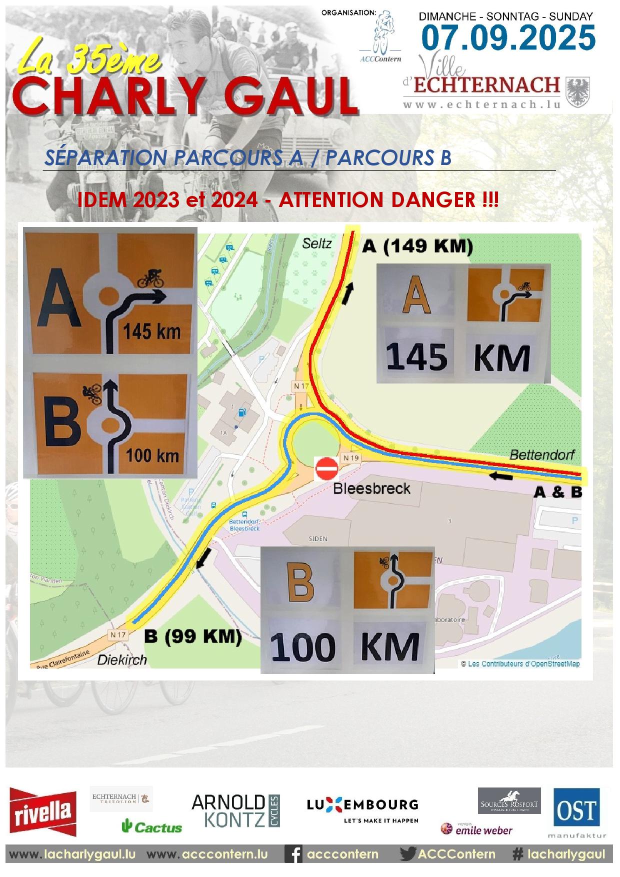
SEPARATION A/B
|
N17
|
123
|
192
|
|
27
|
Seltz
|
|
CR353
|
122
|
201
|
|
29
|
Bastendorf
|
|
|
|
122
|
201
|
|
32
|
Brandenbourg
|
|
|
|
117
|
266
|
|
37
|
Gralingen
|
|
CR320a
|
112
|
491
|
|
39
|
Merscheid
|
RAVITAILLEMENT
|
CR320
|
110
|
485
|
|
41
|
Hoscheid
|
|
|
|
108
|
484
|
|
45
|
Schlinder
|
|
N27
|
104
|
232
|
|
47
|
Goebelsmühle
|
|
CR348
|
102
|
236
|
|
49
|
Schlindermanderscheid
|
|
|
100
|
386
|
|
51
|
Friidbesch
|
|
|
|
98
|
442
|
|
54
|
Consthum
|
|
CR322
|
95
|
494
|
|
56
|
Holzthum
|
|
|
|
93
|
517
|
|
57
|
Schinker
|
|
|
|
92
|
520
|
|
59
|
Wahlhausen (entrée)
|
|
|
90
|
525
|
|
62
|
Mairie de Putscheid
|
|
CR353
|
87
|
442
|
|
70
|
Brandenbourg
|
|
|
|
79
|
266
|
|
73
|
Bastendorf
|
|
|
|
76
|
231
|
|
75
|
Seltz
|
|
N17
|
74
|
201
|
|
76
|
Bleesbreck
|
REUNION A/B
|
|
|
73
|
192
|
|
77
|
Diekirch (entrée)
|
|
CR322
|
72
|
192
|
|
78
|
Gilsdorf
|
|
CR356
|
71
|
190
|
|
80
|
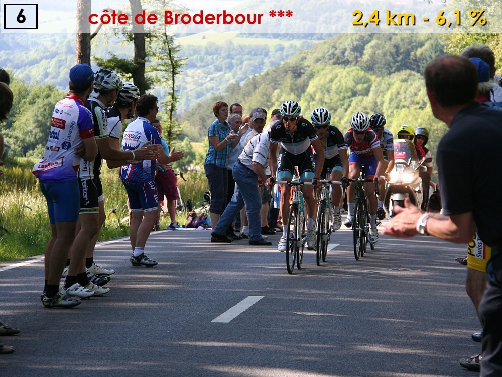
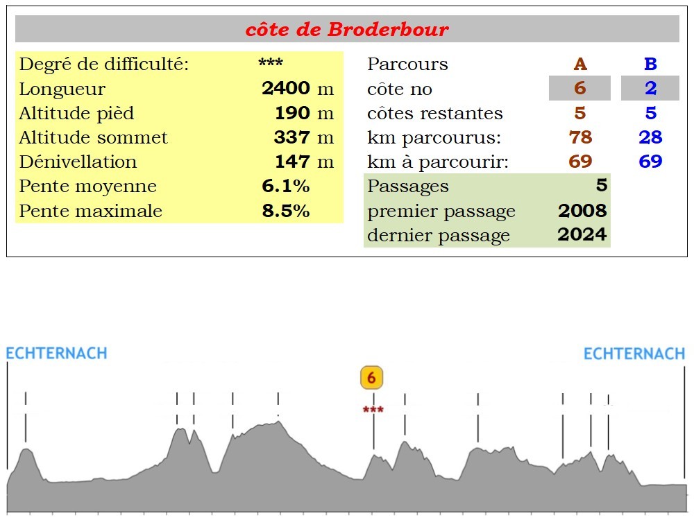
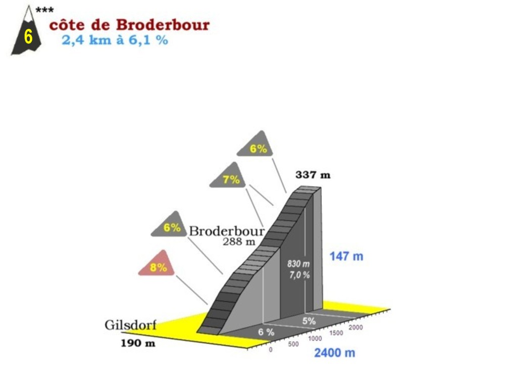
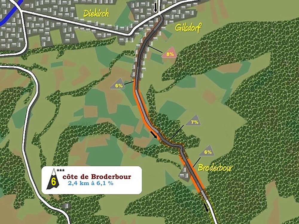
Broderbour
|
|
|
|
69
|
371
|
|
84
|
Ermsdorf
|
RAVITAILLEMENT
|
CR358
|
65
|
245
|
|
89
|
Savelborn
|
|
|
|
60
|
365
|
|
91
|
Christnach
|
|
CR128
|
58
|
309
|
|
92
|
Waldbillig
|
|
CR356
|
57
|
304
|
|
94
|
Mullerthal
|
|
CR121
|
55
|
213
|
|
99
|
Vugelsmillen
|
|
CR364
|
50
|
193
|
|
103
|
Berdorf
|
|
|
|
45
|
371
|
|
108
|
Consdorf
|
|
|
|
41
|
350
|
|
113
|
Bech
|
|
|
|
36
|
297
|
|
116
|
Berbourg
|
|
|
|
33
|
273
|
|
120
|
Manternach (entrée)
|
CR139
|
29
|
268
|
|
121
|
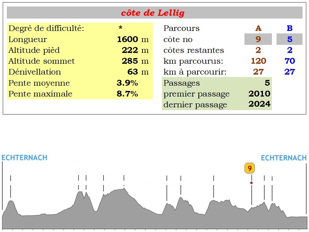
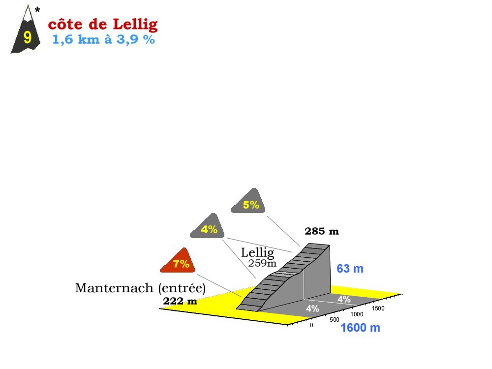
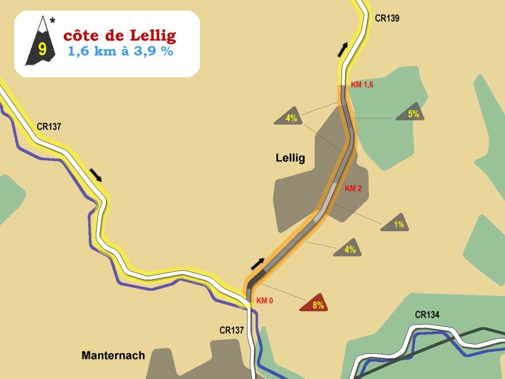
Lellig
|
|
|
|
28
|
286
|
|
125
|
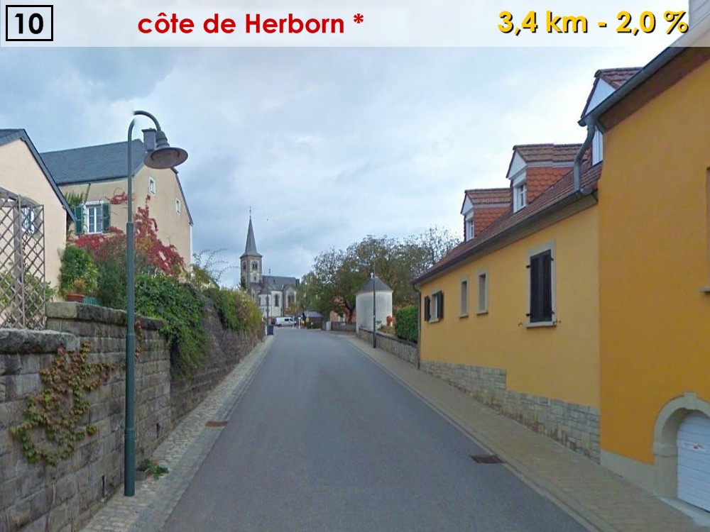
Herborn
|
|
|
|
24
|
296
|
|
|
|
RAVITAILLEMENT
|
|
|
|
|
130
|
Osweiler
|
|
CR141
|
19
|
237
|
|
133
|
Dickweiler
|
|
CR370
|
16
|
295
|
|
136
|
Girst
|
|
|
|
13
|
225
|
|
138
|
Hinkel
|
|
PC3
|
11
|
165
|
|
141
|
Rosport
|
|
N10
|
8
|
160
|
|
144
|
Steinheim
|
|
|
|
5
|
157
|
|
149
|
ECHTERNACH
|
ARRIVEE
|
|
|
0
|
160
|
|
|
|
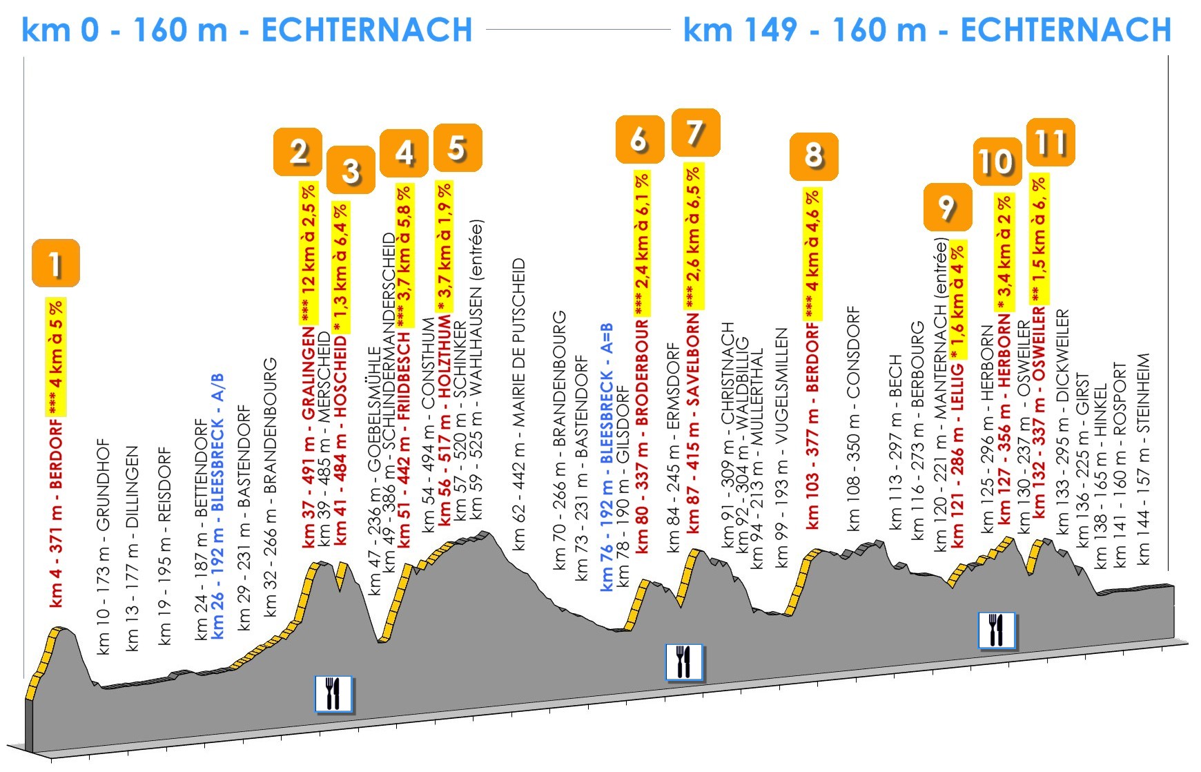
DENIVELLATION TOTALE: 2.005 m
|
|
|
|
|
|
|
|
|
|
|
|
|
|
|
|
|
|
|
|
|
|
Départ à 9h30 sur la place du Marché à Echternach
|
|
km +
|
Localité
|
Remarque
|
Route
|
km -
|
Alt
|
|
|
|
0
|
ECHTERNACH
|
DEPART
|
CR364
|
99
|
160
|
|
4
|
Berdorf
|
|
|
|
95
|
371
|
|
8
|
Vugelsmillen
|
|
CR121
|
91
|
187
|
|
10
|
Grundhof
|
|
N10
|
89
|
173
|
|
13
|
Dillingen
|
|
|
|
86
|
177
|
|
19
|
Reisdorf
|
|
N19
|
80
|
195
|
|
22
|
Moestroff
|
|
|
|
77
|
186
|
|
24
|
Bettendorf
|
|
|
|
75
|
187
|
|
26
|
Bleesbreck
|
SEPARATION A/B
|
N17
|
73
|
192
|
|
27
|
Diekirch (entrée)
|
|
CR322
|
72
|
192
|
|
28
|
Gilsdorf
|
|
CR356
|
71
|
190
|
|
30
|
Broderbour
|
|
|
|
69
|
371
|
|
34
|
Ermsdorf
|
RAVITAILLEMENT
|
CR358
|
65
|
245
|
|
39
|
Savelborn
|
|
|
|
60
|
365
|
|
41
|
Christnach
|
|
CR128
|
58
|
309
|
|
42
|
Waldbillig
|
|
CR356
|
57
|
304
|
|
44
|
Mullerthal
|
|
CR121
|
55
|
213
|
|
49
|
Vugelsmillen
|
|
CR364
|
50
|
193
|
|
53
|
Berdorf
|
|
|
|
45
|
371
|
|
58
|
Consdorf
|
|
|
|
41
|
350
|
|
63
|
Bech
|
|
|
|
36
|
297
|
|
66
|
Berbourg
|
|
|
|
33
|
273
|
|
70
|
Manternach (entrée)
|
CR139
|
29
|
268
|
|
71
|
Lellig
|
|
|
|
28
|
286
|
|
75
|
Herborn
|
|
|
|
24
|
296
|
|
|
|
RAVITAILLEMENT
|
|
|
|
|
80
|
Osweiler
|
|
CR141
|
19
|
237
|
|
83
|
Dickweiler
|
|
CR370
|
16
|
295
|
|
86
|
Girst
|
|
|
|
13
|
225
|
|
88
|
Hinkel
|
|
PC3
|
11
|
165
|
|
91
|
Rosport
|
|
N10
|
8
|
160
|
|
94
|
Steinheim
|
|
|
|
5
|
157
|
|
99
|
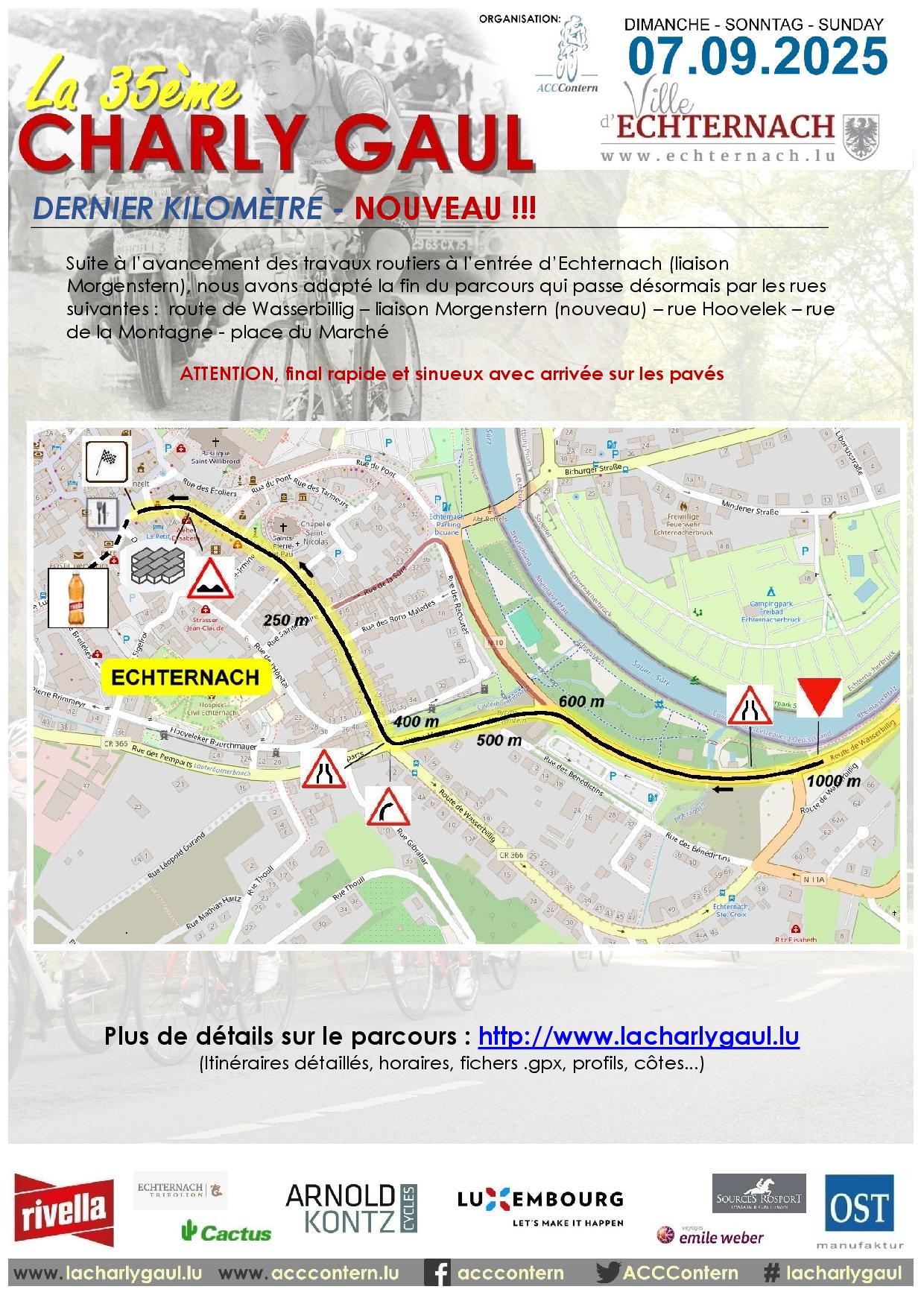
ECHTERNACH
|
ARRIVEE
|
|
|
0
|
160
|
|
|
|
DENIVELLATION TOTALE: 1.244 m
|
|
|
|
|
|
|
|
|
|
|
|
|
|
|
|
|
sous réserve de modifications
|
Vous pouvez télécharger ici les itinéraires détaillés des deux parcours proposés par la La 35ème Charly Gaul, sous forme de document imprimable en format .pdf ou sous formes de fichiers .kml ou .gpx à utiliser dans vos systèmes de navigation.
|
Vous avez besoin de l'Adobe Acrobat Reader pour pouvoir lire ces document. Si vous n'avez pas ce logiciel, cliquez ici pour le télécharger et l'installer gratuitement.
sous réserve de modifications
CARTE GENERALE
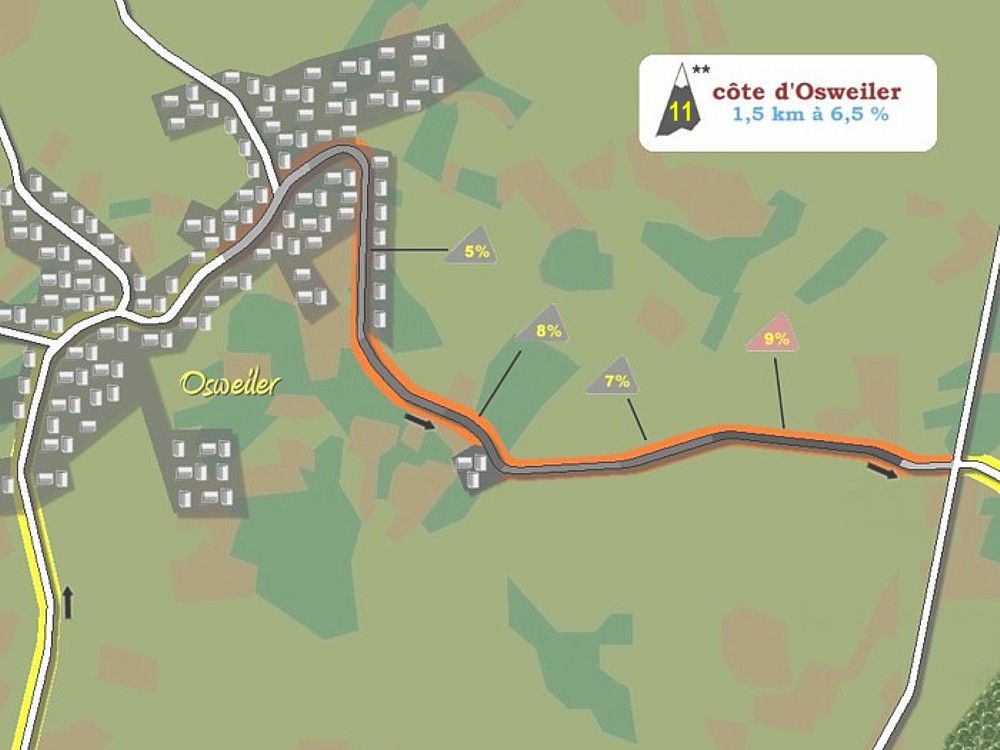
CARTE DETAILLEE PARCOURS A - 149 km (map.geoportail.lu)
CARTE DETAILLEE PARCOURS B - 99 km (map.geoportail.lu)
sous réserve de modifications
PROFIL PARCOURS A (149 km)
PROFIL PARCOURS B (99 km)
sous réserve de modifications
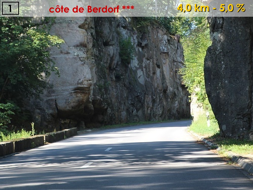
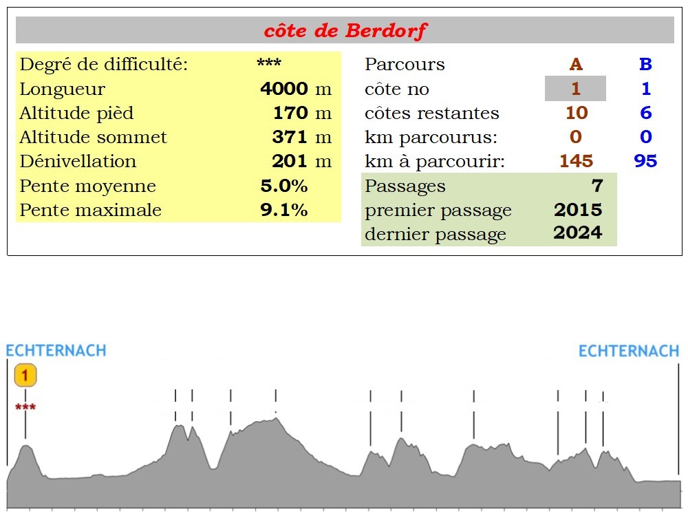
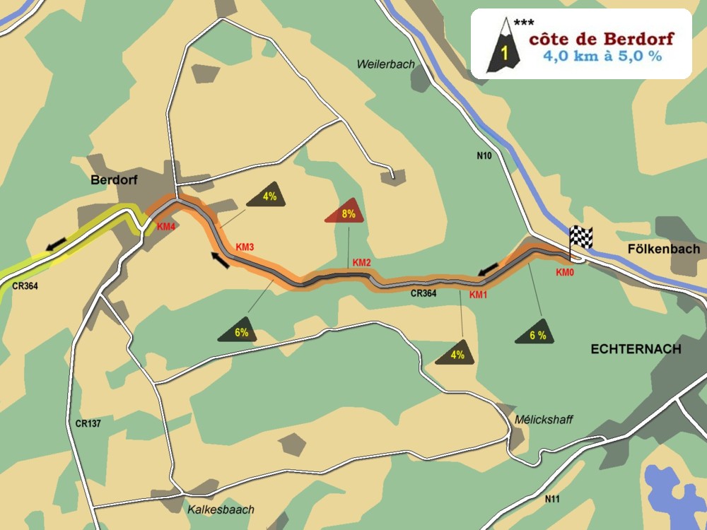
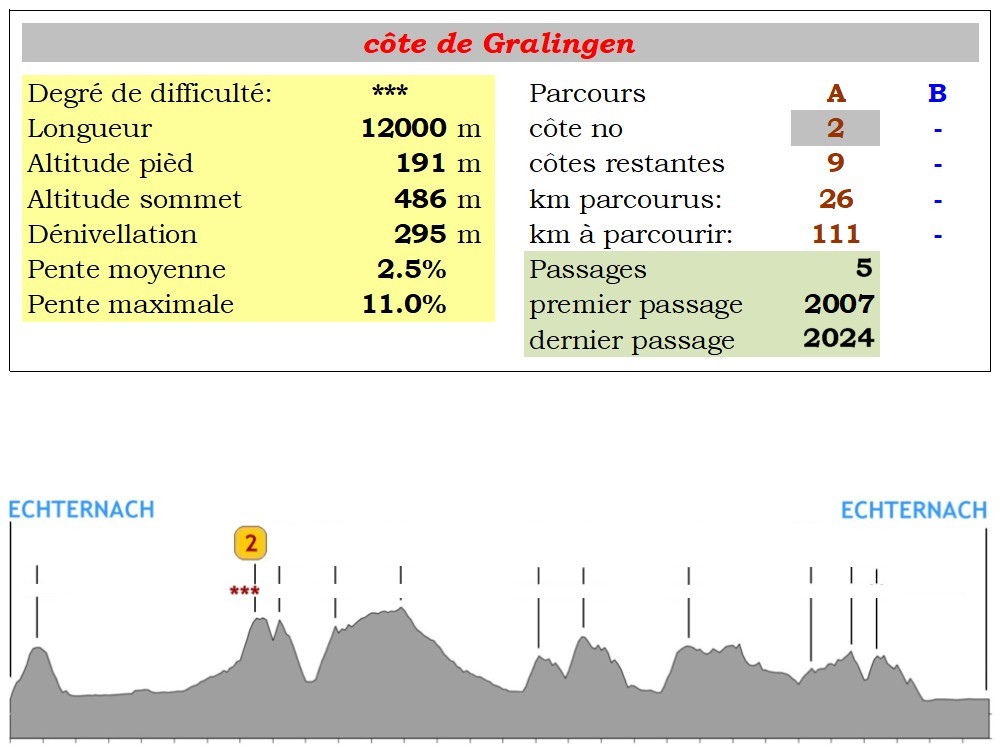
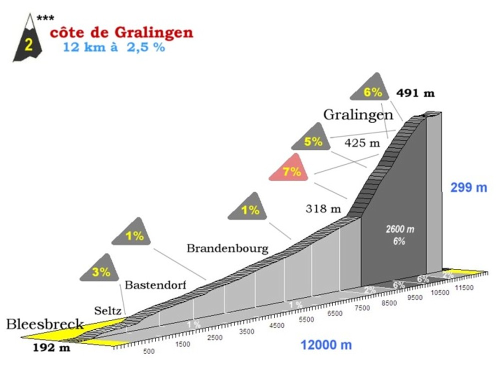
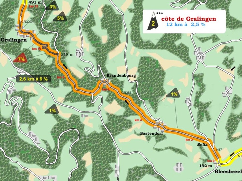
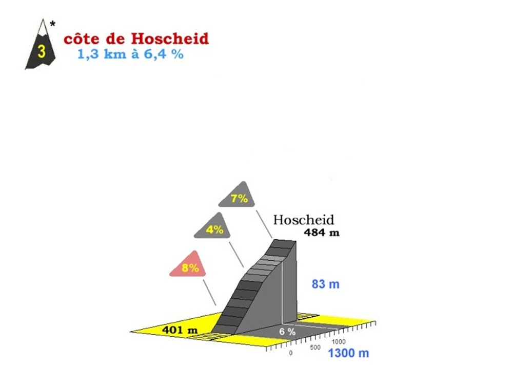
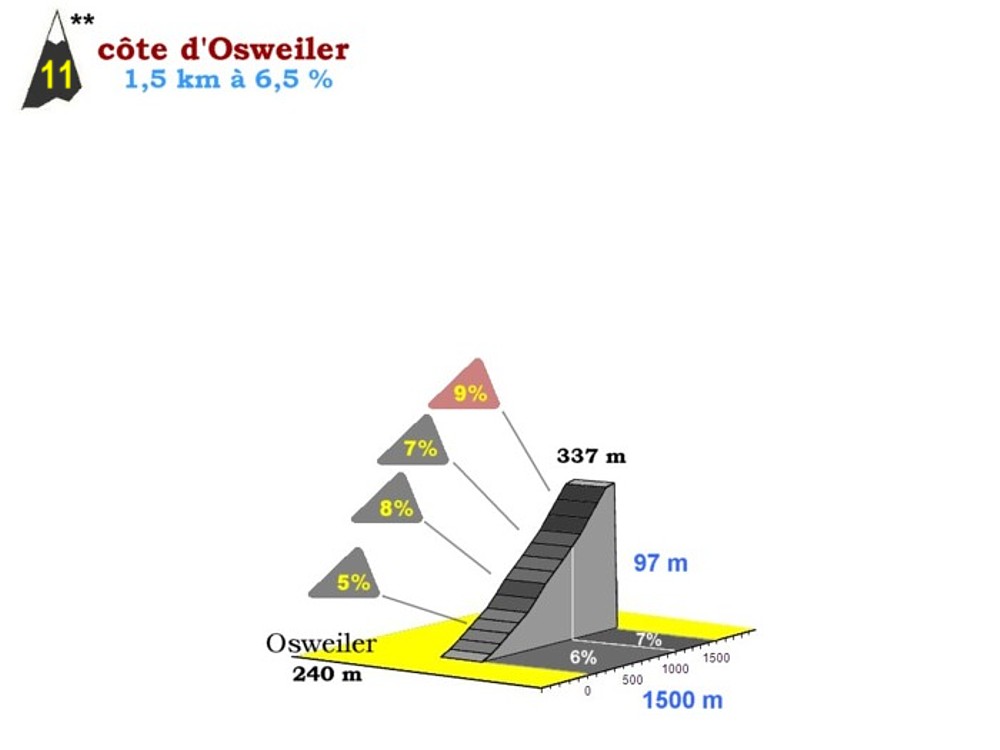
Vous pouvez trouver ci-après quelques informations sur les différentes côtes que vous pouvez rencontrer lors de La 33ème Charly Gaul:
|
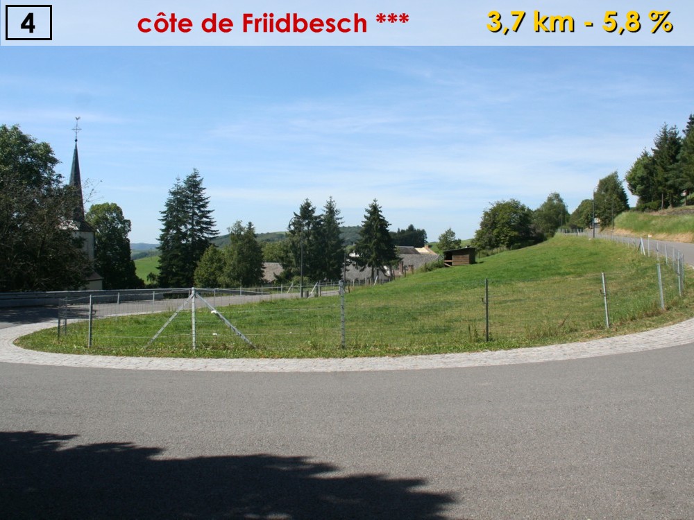
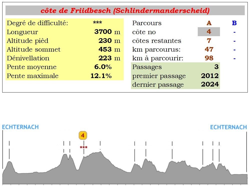
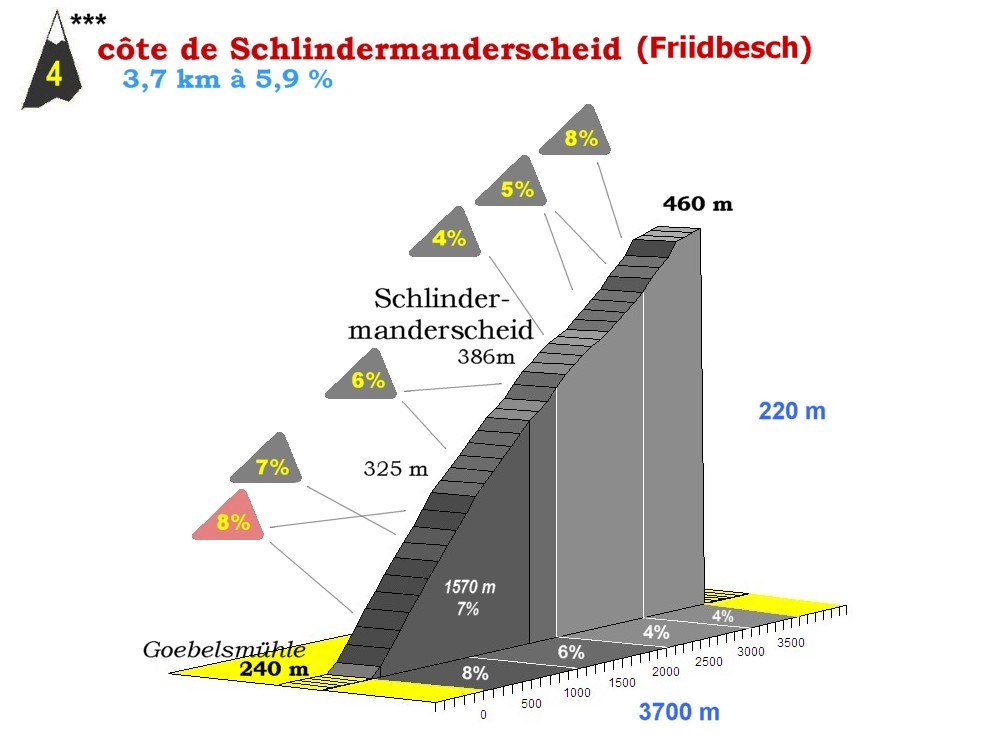
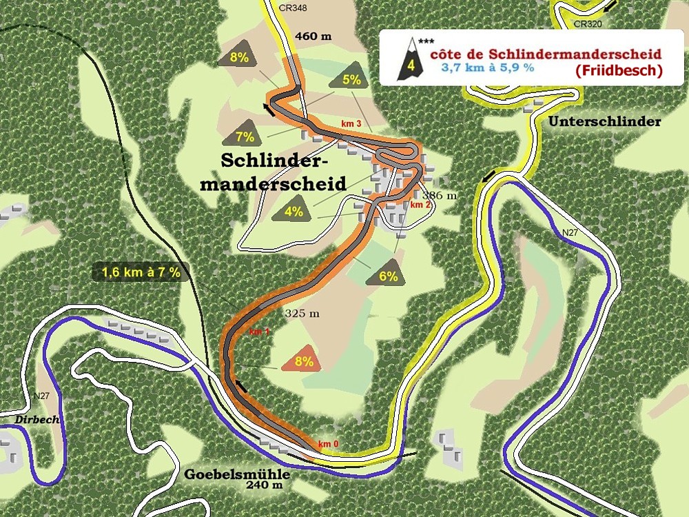
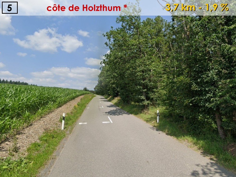
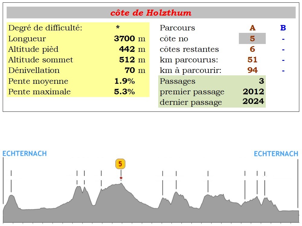
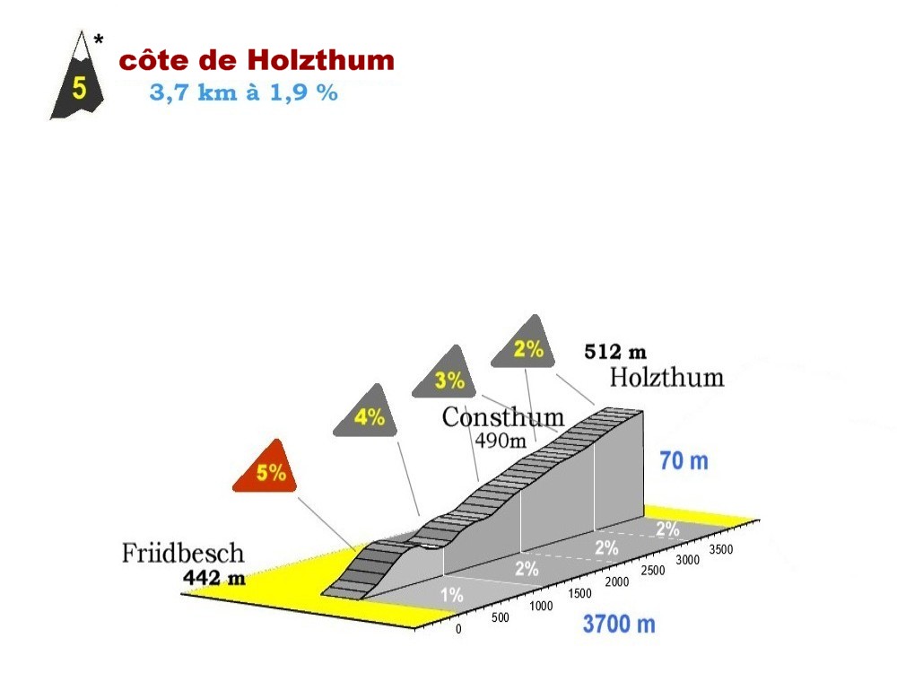
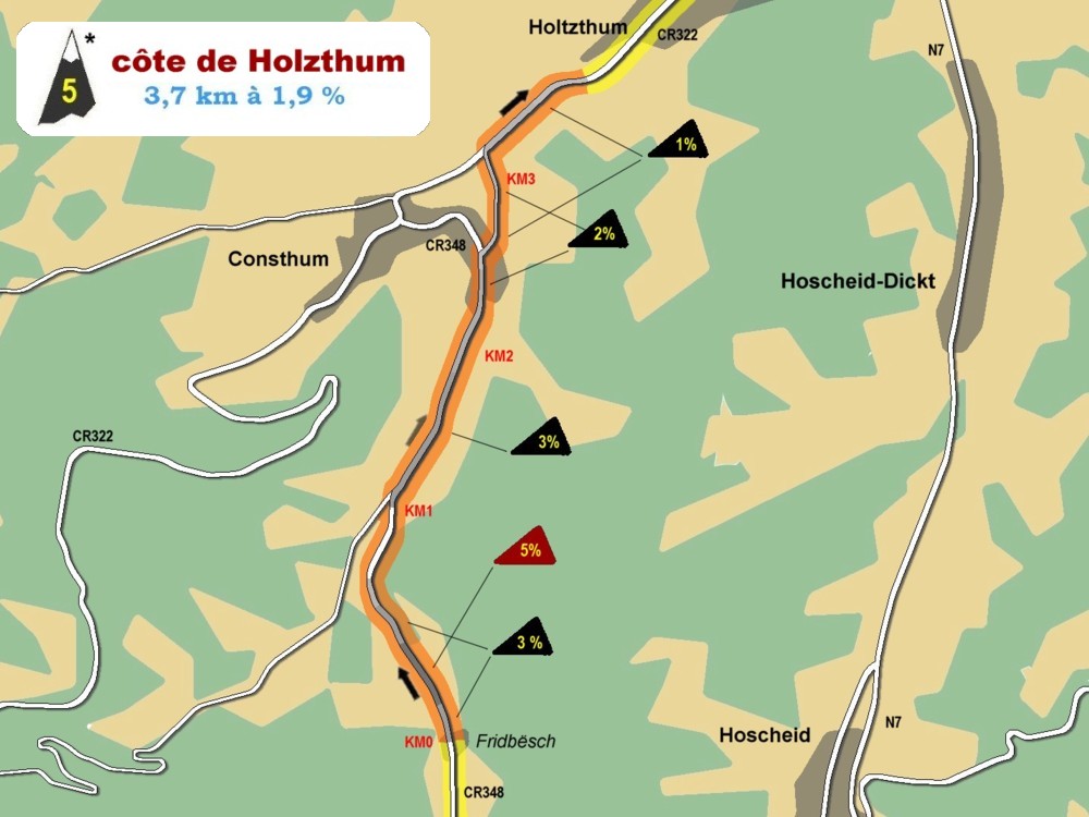
côte de Friidbesch (Schlindermanderscheid)
|
|
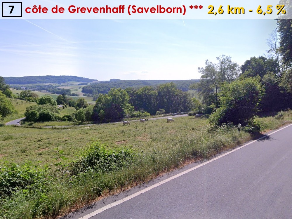
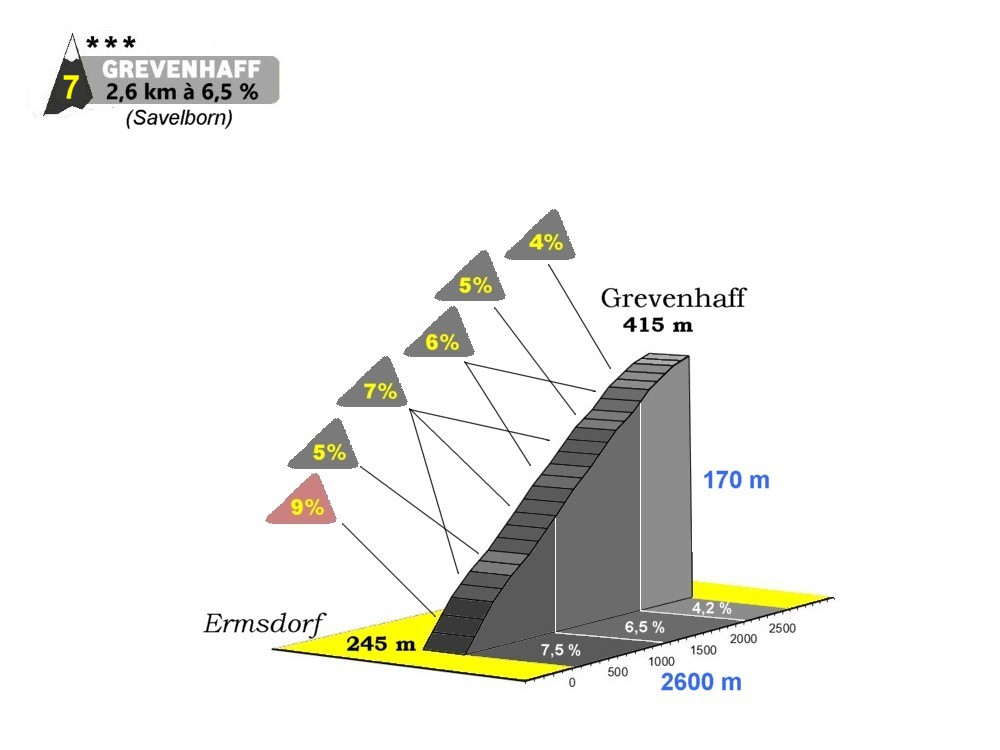
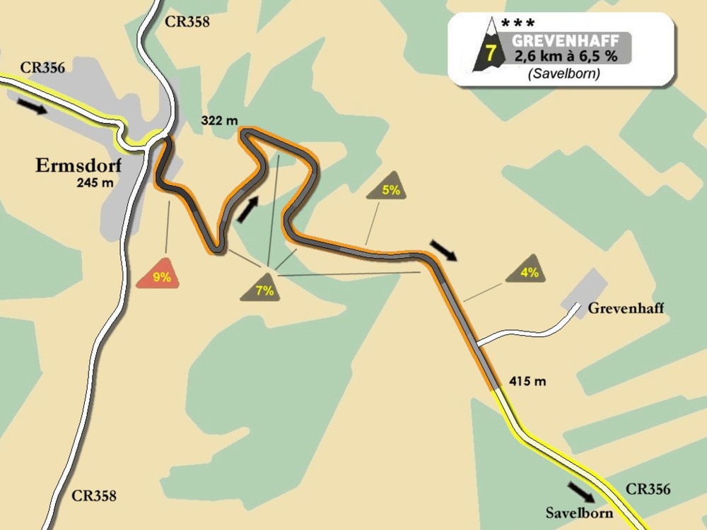
côte de Grevenhaff (Savelborn)
|
|
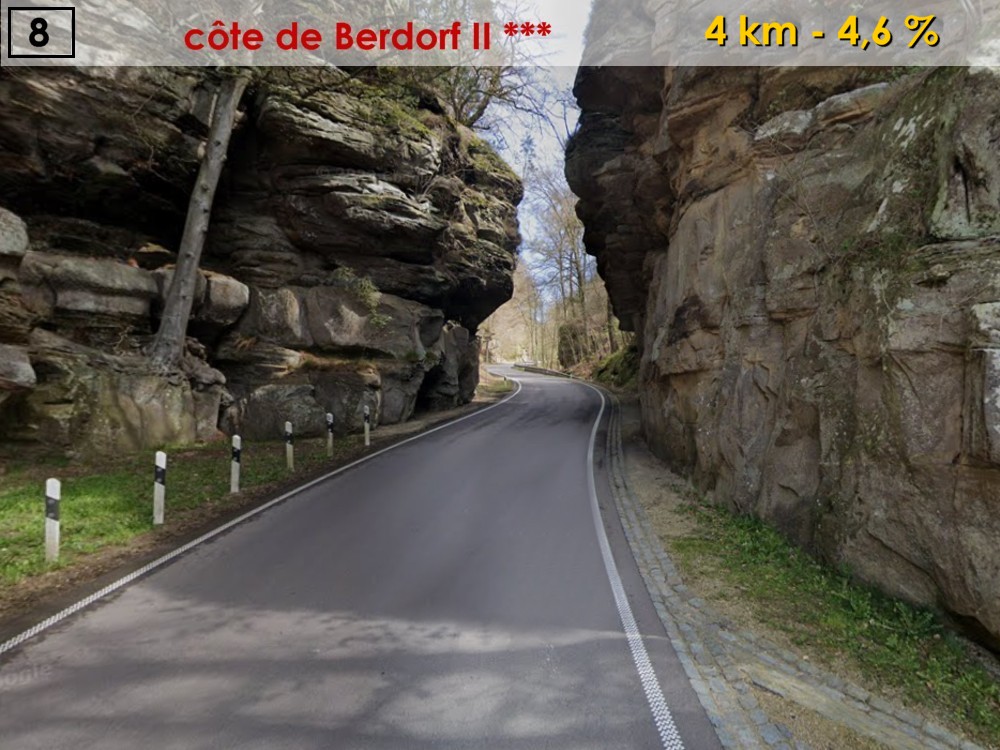
côte de Berdorf II (Vugelsmillen)
|
|
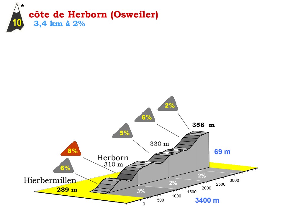
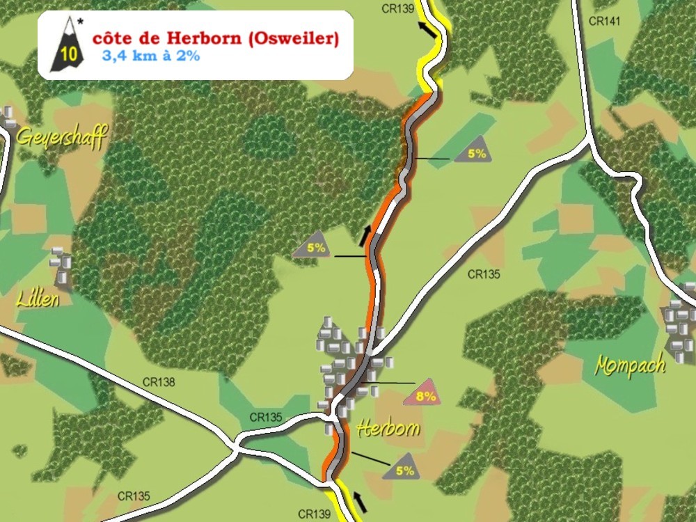
côte de Herborn (Osweiler)
|
ATTENTION DANGER !!!
La Charly Gaul a lieu sur le réseau routier public ouvert au trafic et, malgré tous les soins déployés dans la recherche des itinéraires, les parcours comportent des passages périlleux, surtout dans les descentes ou les traversées de localités. D'autre part, avec l’aide de la Police Grand-Ducale, nous pouvons assurer la priorité de la course sur l’ensemble du tracé. Mais cette mesure concerne uniquement la priorité aux carrefours, du traffic en sens inverse de la course est toujours possible et la législation en vigueur ne nous permet pas de l’étendre au-delà d’une heure. Tous les concurrents avec un retard supérieur à une heure sur le premier coureur de la course perdent donc la priorité sur les carrefours, garantie jusque-là par des agents de police.
Vous pouvez télécharger ci-dessous une liste avec les principaux points et carrefours dangereux sur le parcours
(en format .pdf).

Pour votre propre sécurité, veillez toujours à rester sur le côté droit de la route!
Nous vous demandons également de faire attention aux vols de vélos, de plus en plus nombreux dans le pays depuis quelques années.
RESTEZ VIGILANTS ET NE QUITTEZ PAS VOTRE VELO DES YEUX !!! |

|

|

|

|

|

|

|

|
|